Enabling high-accuracy HYPSO image georeferencing by high-accuracy satellite pose estimation through postprocessing of satelitte sensor data
Project description
The HYPSO program provides and will provide data products to researchers in need of Earth observation data. This project is addressing the challenge of the accurate satellite pose estimation (position and attitude) required to achieve high accuracy georeferencing of images captured in low Earth orbit (LEO). For a LEO satellite at 2000 km altitude a pitch angle error of 0.1 degrees results in a longitudinal pixel georeferencing error of ~3.5 km on the ground. A 0.1-degree roll error will result in a similar traverse error. Any yaw error will corrupt any photo mosaic using images from multiple satellite passes. It is well known that if the data is not required in real time, a process processing can be used. For pose estimation with the available sensors this postprocessing is often referred to as smoothing [1]. This is the type of method that will be deployed in this project. An image taken by HYPSO-1 that has been georeferenced can be seen in Figure 1.
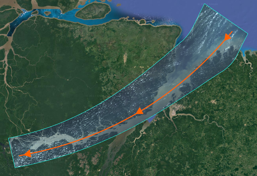
Figure 1: Georeferenced image by HYPSO-1* over a river, image displayed over a representation of the Earth. This georeferencing would be more difficult without these clear geographical features, which would be the case in open waters, a problem this project hopes to address. Credit: [3]. *HYPSO-1 takes hyperspectral images, which are hard to visualize. This image uses a small subset of the HYPSO-1 data to produce the image.
Impact of this project
Space technology plays a critical role in achieving 40% to 50% of the UN Sustainable Development Goals. The NTNU SmallSat Lab's HYPSO satellites, launched in 2022 and with a successor planned, utilize hyperspectral imagers to capture detailed information beyond the visible. This data allows us to detect and monitor water bodies like oceans, fjords, and lakes, including vital yet potentially harmful algae. The HYPSO satellites also contribute to climate change studies by imaging the Arctic region. Data from the HYPSO satellites play a role in achieving Climate Action, Preserving Life Below Water, and ensure access to Clean Water and Sanitation. The objective of this project is to get the satellite to be able to accurately determine where it has been pointing, and thus it would enable the HYPSO-satellites to detect and localize algal blooms even further away from a coastline.
Tasks in this project
- Perform a short literary review on the smoothing algorithms for navigation including such as Kalman filter based smoothers such as RTS, Fraser-Potter [1] and factor-graph-based optimization techniques (FGO) [2].
- Set up a simulation of sensors or observation techniques such as Two-line element [https://en.wikipedia.org/wiki/Two-line_element_set], IMU, Sun sensor, star tracker and GNSS measurements.
- Implement smoothing algorithms based on the simulation .
- Compare the proposed algorithms using telemetry data.
- Collaborate with other students or researcher to verify the improvements made in georeferencing.
Who we are looking for
We are seeking a highly motivated final year student in Cybernetics and Robotics with interest in sensor fusion and georeferencing. Experience from subjects such as TTK4250 (Sensor fusion) and TTK4190 (Guidance, Navigation and Control of Vehicles) will be beneficial for the student in this project. The project will be adapted to the student's background and goals.
How we work
The student will be part of the NTNU SmallSat lab, a lab which typically hosts 10-20 master's student per semester. At the NTNU SmallSat Lab we encourage collaboration and try to get our group to help each other. To facilitate this, we encourage the students to meet us in the lab as well as arrange common lunches and workshops where the students and supervisors can learn from each other.
Supervisors
Torleiv H. Bryne (main supervisor, NTNU), Bjørn Andreas Kristiansen (NTNU).
For more information about the project, contact Torleiv Håland Bryne and Bjørn A. Kristiansen
References
[1] Carpenter and D'Souza (2018) Navigation Filter Best Practices, NASA/TP--2018—219822, https://tinyurl.com/4az7ycs9
[2] Dellaert and Kaess (2017), Factor Graphs for Robot Perception, Foundations and Trends in Robotics, 6-(1:2), pp1-139, https://doi.org/10.1561/2300000043
[3] Langer, D.D., Garrett, J.L., Kristiansen, B.A., Birkeland, R., Bakken, S., Berg, S., Gravdahl, J.T., Johansen, T.A., Sørensen, A.J., 2024. Agile Maneuvers for Push-Broom Imaging Satellites. IEEE Trans. Geosci. Remote Sens., submitted.